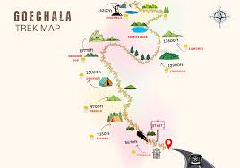
The Goechala Trek Map is an essential tool for anyone planning to explore one of the most scenic high-altitude treks in India. Located in West Sikkim, the Goechala Trek offers breathtaking views of Mount Kanchenjunga, alpine forests, glacial valleys, and expansive meadows. Understanding the trek map helps trekkers visualize the route, plan daily distances, and prepare for altitude changes.
At Glacier Treks And Adventure, we strongly recommend studying the Goechala Trek Map before starting the journey. A clear understanding of the route improves safety, confidence, and overall trekking experience.
Why the Goechala Trek Map Is Important
The Goechala Trek Map provides a clear overview of the trekking trail from Yuksom to Goechala View Point. It highlights campsites, river crossings, ascents, descents, and altitude variations. Since this trek passes through protected forest areas and high-altitude zones, route awareness becomes even more important.
Moreover, the map helps trekkers manage energy levels and acclimatisation properly. Knowing what lies ahead allows better preparation for long walking hours and changing terrain.
Overview of the Goechala Trek Route
The Goechala Trek Map starts from Yuksom, the historical town in Sikkim, and gradually moves deeper into the Kanchenjunga National Park. The trail follows river valleys, forest paths, and alpine ridges before reaching the iconic Goechala View Point.
Key highlights shown on the map include dense rhododendron forests, wooden bridges, open grasslands, and glacial moraines. Each section of the route presents a different landscape, making the trek visually diverse.
Starting Point on the Goechala Trek Map: Yuksom
Yuksom marks the beginning of the trek and is clearly indicated on the Goechala Trek Map. Located at an altitude of approximately 5,600 feet, Yuksom serves as the base camp where permits are checked and final preparations are completed.
The trail from Yuksom enters thick forest cover and follows the Rathong River. The gradual ascent makes this section suitable for initial acclimatisation.
Sachen: First Campsite on the Map
The next major point on the Goechala Trek Map is Sachen. This campsite lies deep inside the forest and is surrounded by tall trees. The route from Yuksom to Sachen includes gentle climbs and river crossings.
Sachen plays an important role in the trek as it allows trekkers to adapt to trekking conditions without sudden altitude gain.
Tshokha: A Major Halt on the Goechala Trek Map
Tshokha is a key location on the Goechala Trek Map and one of the most scenic campsites. The trail to Tshokha becomes steeper and passes through dense rhododendron forests.
On the map, Tshokha appears as a significant altitude jump, making it an important acclimatisation stop. Clear weather offers early views of Himalayan peaks from this point.
Dzongri: High-Altitude Meadow Zone
Dzongri is prominently marked on the Goechala Trek Map as a high-altitude camping area. The route from Tshokha to Dzongri opens into vast meadows with panoramic mountain views.
The map indicates Dzongri as a crucial acclimatisation zone due to its altitude. Many trekkers spend an extra day here to adjust before moving further.
Dzongri Top on the Trek Map
Just above Dzongri, the Goechala Trek Map highlights Dzongri Top, a popular viewpoint. Although not a campsite, this location is known for sunrise views over Kanchenjunga, Pandim, and Kabru peaks.
The short climb to Dzongri Top is often included for acclimatisation and scenic photography.
Kokchurang: Valley Section of the Map
Descending from Dzongri, the trail leads to Kokchurang, clearly marked on the Goechala Trek Map as a riverside campsite. This section shows a change in terrain, moving from open meadows to valley landscapes.
The map indicates river crossings and gradual ascents, helping trekkers prepare for longer walking hours.
Thansing: Wide Meadow Campsite
Thansing is an important point on the Goechala Trek Map and one of the largest camping areas. Surrounded by towering peaks, this meadow serves as a base for the final ascent to Goechala View Point.
The map shows Thansing as a strategic halt where trekkers rest before the summit day.
Lamuney: Final Campsite Before Goechala
Lamuney appears on the Goechala Trek Map as the last campsite before the final climb. The route from Thansing to Lamuney is relatively short but crucial for acclimatisation.
Studying this section on the map helps trekkers plan an early start for the summit push.
Goechala View Point on the Trek Map
The Goechala Trek Map clearly marks Goechala View Point 1 as the highest and most rewarding location on the route. The trail from Lamuney involves early morning trekking over rocky and icy terrain.
This viewpoint offers the closest panoramic view of Mount Kanchenjunga and surrounding glaciers, making it the highlight of the trek.
Descent Route Shown on the Goechala Trek Map
After reaching Goechala View Point, the map shows the return route following the same trail back through Thansing, Tshokha, and finally Yuksom. Although descending, this section still requires endurance due to long distances.
Understanding the descent route on the map helps trekkers pace themselves and avoid fatigue.
Best Time to Use the Goechala Trek Map
The map is most useful during spring and autumn seasons. In spring, blooming rhododendrons and stable weather make navigation easier. In autumn, clear skies offer excellent visibility of the terrain shown on the map.
Winter and monsoon seasons are not recommended due to snow cover and landslide risks.
How Glacier Treks And Adventure Uses the Trek Map
At Glacier Treks And Adventure, the Goechala Trek Map is used to design safe itineraries, manage daily distances, and ensure proper acclimatisation. Our experienced team understands every section of the route and plans the trek accordingly.
The map allows us to monitor progress, manage rest days, and adapt to weather conditions efficiently.
Conclusion
The Goechala Trek Map is more than just a route diagram. It is a complete guide that helps trekkers understand terrain, altitude changes, campsites, and daily trekking challenges. A well-studied map enhances safety, confidence, and enjoyment throughout the journey.
With proper planning and expert guidance from Glacier Treks And Adventure, the Goechala Trek becomes a well-structured and unforgettable Himalayan experience. If you are preparing for this iconic trek, start by understanding the map and let the mountains guide your path.